
Strata Dusteburg
High Wycombe, Buckinghamshire. Local History
Old roads through High Wycombe
In the Middle Ages, the east to west highway through Wycombe was not along the A 40, but was to the south of the River Wye. In fact Estynton = East Town = Easton Street only led to St. John's Hospital whose grounds extended as far as the River ( Parker page 34). Probably the through road from Easton St. towards Loudwater was opened towards the end of the 16th century.
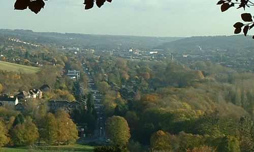
The old road from Loudwater ( Lude in Domesday ) to West Wycombe was along the course of Desborough Road from the Gas Works to Green Street School. In 1230 it was called Strata Dusteburg and was probably a British / Roman road continuing from the Pedestal past a Roman villa at Saunderton to the Icknield Way ( Ashford p. 31). Dusteburg is a variation on Dustenberg as referred to in the Domesday Book of 1086 - The Desborough Hundreds.
From a point just to the south of the present bridge over the Wye near the Police Station, the road to the east followed the line of the Dyke, past the site of the Roman Villa (destroyed by the Council when the swimming baths were built ) and then probably followed Back Lane to Loudwater and Windsor. The connection to the road to Beaconsfield could have been along Glory Mill Lane ( now cut off by the M 40 ) which led to the top of White Hill. The section of road now under the Dyke was enclosed in the grounds of Loakes Manor - now Wycombe Abbey - together with the westward section of the old road towards its crossing of St.Mary's St.
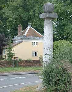
Sir John's new road, from the top of West Wycombe Hill
To the west, it is not clear where this road joined the old West Wycombe Road from Oxford Road to the Pedestal. Before Sir John Dashwood built the existing straight road, using material excavated from the caves under West Wycombe Hill, the alignment of the road to West Wycombe followed the River from Ash Mill (Westbourne Street) along Nutfield Row to the "Bird-in-Hand" public house, through the yard of V. M. Millbourn's former furniture factory to Lower Mill End, along Gillett's Lane, then through West Wycombe Park, as shown clearly on the 1st edition Ordnance Survey map, to the Pedestal.
Probably the dog-leg in the old Strata Dusteburg at Green Street school (as on the 1849 Tithe Map) was the result of an early enclosure, and the alignment west of Oakridge Road would appear to have been swallowed up in Dashwood's estate, as, in the 19th century, the only way west from Green Street was along Oakridge Road to the "Bird-in Hand". It is most unlikely that the late Victorian Desborough Street was on the original alignment.
The 1st edition Ordnance Survey map shows an almost straight lane from the lodge gate of Wycombe Abbey , passing through the London Transport garage ( now Staples) to join Newland/Desborough Road between the Gas Works and Newland Methodist chapel. This lane is called Loakes Lane on the map in Parker (1878) and was the Borough boundary until 1880.The western half of this lane had disappeared by the time of the 1897 revision of the Second Edition of the Ordnance Survey map, which was originally surveyed in 1874. The alignment of the eastern half can be followed on this map together with a diversion of 1808 (as a footpath) which brought the exit into St. Mary's Street some 50 yards north of the original junction. It is possible that the original Lily's Walk was a diversion constructed when the original Loakes Lane was closed, between the survey of 1874 and the 1897 revision.
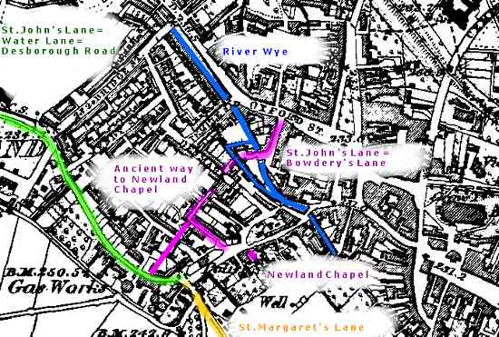
Image produced from the www.old-maps.co.uk service with permission of
Landmark Information Group Ltd. and Ordnance Survey
New names
What were these lanes called after the name Strata Dusteberg was no longer used?Parker states on p. 33 that Loakes Lane was formerly called St. Margaret's Lane. Ashford states on p.27 that Desborough Road was called St. Margaret's Lane in the 16th century. Evidence to support this occurs in the Title Deeds of the Goodearl furniture factories where deed No. 122 refers to the Hop Garden. This was a plot of land on the north side of Desborough Road between Mendy Street and the Gas Works. In a deed of 1658 the Hop Garden is stated to be "bounded on the south by a lane between Newland and St. Margaret's" and another of 1669 refers to "a lane to St. Margaret's on the south".
Copies of a sketch map of 1596 in the County Records Office and Wycombe Library concerning land belonging to All Souls College,Oxford, near Ash Mill refers to "a lane leading from St. Margaretts to Wikham". This map shows a building along this lane some 200 yards west of the junction with what is now Westbourne Street. Ashford considers that this is the site of St.Margaret & St.Giles Leper Hospital (St. Giles was the patron saint of lepers). This is confirmed by some excavations carried out at the Desborough Road/Avenue cross-roads where some skeletons were discovered without fingers. These were obviously lepers, and the location of the graves coincides with the position of the building on the 1596 map.
The Dyke, constucted over the line of the old road east of the Town.
200 years later, deeds for the site of the "Peacock" public house in Mendy Street of 1799 refer to the road as St. John's Lane, and deeds from 1844 to 1863 say "St. John's or Water Lane". By the time of the 1874 Ordnance Survey map, it had become Water Lane, no doubt on account of the frequent flooding in the area. Sometimes it was called Watery Lane, while the 1849 Tithe Map has Walterup Lane. At the 1891 census it was known as Desborough Road.
The origin of the name St. John's Lane is something of a mystery. The church of St. John's was only built in 1901, so the lane was not named after that. Parker's sketch map shows Bowdery's Lane - the short lane from Oxford Street to Temple Mill - as St. John's Lane, and Goodearl Deeds No.98 of 1865 refer to a property in "St. John's Lane - now Bowdery's Lane". Why are there two St. John's Lanes at the west end of the town when the only building named after a St. John was the hospital of St. John the Baptist at the end of Easton Street?
Originally there was only one bridge across the Wye - Bynethe Bridge in St. Mary's Street - other crossings being fords. A mill is a likely location for a ford, as at present at the crossing of the River Misbourne at Chalfont Mill near Chalfont St. Giles, so probably there was a ford at Temple Mill. This is almost certainly one of the 6 Wycombe mills listed in the Domesday Book, the others probably being Ash, Bridge, Pann, Bassetsbury and Marsh.
As its name suggests, New Land was not part of ancient Wycombe, so the river crossing at the location of Newland Bridge would have been later than that at Temple Mill. A route across the ford would have led to the main highway in the Wye valley - the Strata Dusteburg. On the 1874 Ordnance Survey map, the alignment of access ways from Denmark Street to Albert Place, the "Barley Mow" and Miller's Row, together with the boundary of a vacant plot north of Denmark Street lead directly to the mill and could be the link between the two St. John's Lanes.
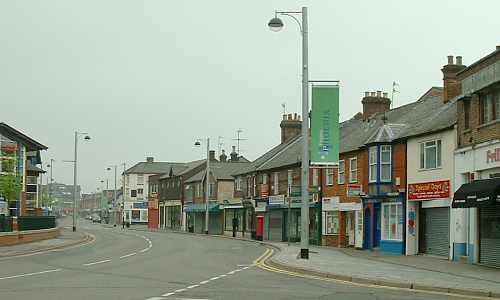
Desborough Road at the junction with Bridge Street.
As a further clue, Goodearl Deed No.10 of 1828 concerning the sale of land for 31 terrace cottages in Long Row refers to an ancient way from the vicinity of New Land Chapel to the N.E. corner of the site i.e. between the "Barley Mow" and Miller's Row. In the open meadowland then existing south of the Wye, the "ancient way" surely refers to a lane. The east-west track along Miller's Row could date from 1694 when the Baptists built the chapel. So it is probable that St. John's Lane led from Oxford Street, across the River and along Desborough Road to Green Street.
Clearly Temple Mill was associated with nearby Temple Manor Farm, at Temple End. Lorna Cassidy states on p.21 of "Discovering High Wycombe" that a Knight Templar owned the Manor in the 14th century. As the Templars Order was suppressed in 1313, probably the Manor was transferred to the Knights of St.John of Jerusalem - the other religious order of knights -and the lane to their mill became St. John's Lane.
Related pages:
High Wycombe Water Mills
in the Domesday Book.
All Soul's College properties in Wycombe:
Ash and Temple Mills.
More research is required!
K.A.Goodearl
Chorleywood
U.K.